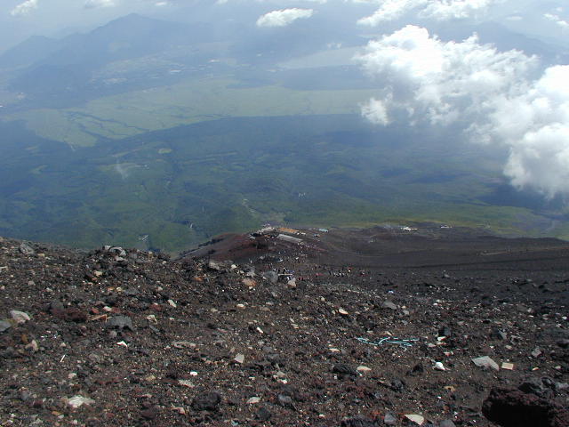
 A
view looking back down the mountain. The trail can be seen running from
the mountain huts in the center across to the right of the picture
A
view looking back down the mountain. The trail can be seen running from
the mountain huts in the center across to the right of the picture
 Return to INSPEC home page
THE ‘SUMMIT’ [and then the REAL SUMMIT !]
A
view looking back down the mountain. The trail can be seen running from
the mountain huts in the center across to the right of the picture
Having passed through the Tori at the top of the trail and taking in the view from the edge of the crater, self congratulations are in order.
However, you have not yet reached the real summit, which is on the opposite side of the crater where the meteorological radar station is located ! In the Summer of 2001 the station is due to be removed after many years of service, so it is not clear what will be there in 2002. At the moment there is a commemorative post next to the meteorological station marking the true summit.
The first thing you should do on reaching the edge of the crater is get your wooden staff stamped or buy a lucky momento in the shrine building immediately at the top of the trail. Then walk clockwise around the crater, unless you want to see the shadow of Fuji when it is somewhat quicker to walk anticlockwise.
Next to the shrine building there are several shops to buy hot food and drink, another tip toilet which uses special bacteria to eat up waste and the descent trail down the mountain next to it [in that order]. Continue to walk around the summit in an anticlockwise direction to the Shizuoka Prefecture side at the southern side where you will find a shrine, another shop for food, a temporary post office and telephones.
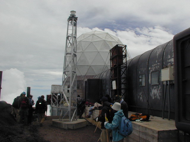 The
real summit. In the autumn of 2001 the meteorological station was removed
The
real summit. In the autumn of 2001 the meteorological station was removed
![]() One
point advice - In this shop don’t forget to seek out an enameled
‘I climbed Fuji 3,776 m’ lapel pin for Yen 500.
One
point advice - In this shop don’t forget to seek out an enameled
‘I climbed Fuji 3,776 m’ lapel pin for Yen 500.
Also, pop into the Post Office. It is very small and you will undoubtedly have to queue and squeeze to get in. Ask for a packet of postage paid postcards which are sold for a few hundred Yen. Then have fun stamping them with several special rubber stamps available there, before passing them back to one of the friendly assistants behind the counter, making sure to check for additional postage to mail them overseas.
Continue clockwise and climb the last outcrop of rock to the summit marker. Congratulations ! You have officially made it to 3,776.5 m
Continuing further clockwise you will look out westwards into the distance towards the Southern Alps, in Nagano Prefecture.
Walking around the northern side you will look out on Yamanashi Prefecture before returning to the point of the first shrine building. Circumnavigation of the summit will take an hour or more depending upon what you stop and do along the way.
 A
view across the crater
A
view across the crater
I stayed on the top of Fuji for about 4 hours. An hour and a half to rehydrate, stretch and have a nap, then to visit the temporary Post Office and eat hot cup noodles on the southern side of the crater and buy my badge, walk the last few metres up to the meteorological station and summit memorial marker on the south-western side, and photograph rock samples partially inside the crater on the north side.
Descent into the deepest part of the crater itself is not possible without specialized equipment and probably not permitted without special permission.
Before starting your descent,
fortify yourself with more supplies and a bathroom break and start your
way back to the 5th station following the wide zigzagging trail which starts
next to the bacteria toilet on the West side.
Return to:
Greetings
Safe trekking advice
Introduction to Fuji
Getting to Fuji
Climbing up
The summit
Climbing down
What to take with you
Last thoughts
Return to INSPEC home page